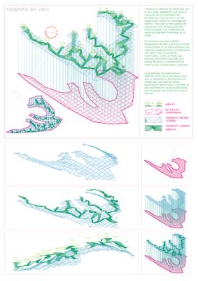
A first study of the method of how to make use of it, proposes a grid for the orchard, an area that had already a form of a grid. It would be a grid of 5 x 5 m and the edges will be different when facing the slope or the orchard. In addition, there is also a possibility of locating the structure 20cm above ground level and in that way enabling irrigation for the orchard.
Topography of the void in the pine wood

The aim is to adapt to the land in as natural way as possible. In order to achieve that, we establish relationships between the topography of the land and the created topography of the trees. We draw a grid from the existing vegetation and we calculate the distance between the ground and the top of tree as a way to study the void under it. We establish different planes that enable the building to intertwine the vegetation.
The protocol of settling into the topography

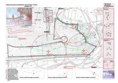
A later study proposes a way of settling into the space keeping a maximum slope of 6%. In principle, we consider that the maximum difference in levels between two connecting points will be 4 metres. In this way, the drawing of the ramp, which will cross the construction, will appear by means of circumferences 60 metres in diameters. From here, one can draw straight lines that can connect different parts of the construction in a comfortable way for the users and with a respect to the land.Furthermore, studies of light have been made as well as of the wind with the purpose of finding the suitable way so as to obtain an optimum ventilation for the construction.
Topography of the void in the pine wood

The aim is to adapt to the land in as natural way as possible. In order to achieve that, we establish relationships between the topography of the land and the created topography of the trees. We draw a grid from the existing vegetation and we calculate the distance between the ground and the top of tree as a way to study the void under it. We establish different planes that enable the building to intertwine the vegetation.
The protocol of settling into the topography

A later study proposes a way of settling into the space keeping a maximum slope of 6%. In principle, we consider that the maximum difference in levels between two connecting points will be 4 metres. In this way, the drawing of the ramp, which will cross the construction, will appear by means of circumferences 60 metres in diameters. From here, one can draw straight lines that can connect different parts of the construction in a comfortable way for the users and with a respect to the land.Furthermore, studies of light have been made as well as of the wind with the purpose of finding the suitable way so as to obtain an optimum ventilation for the construction.


